Monday, October 28, 2024

A Photo Workshop in the Middle of Nowhere

 I have recently returned from a photographic workshop which was held in south-central Utah. Hanksville is a town with no traffic lights, one gas station, two restaurants, and three hotels. Our hotel was our home base for five nights.

Bob and I attended the workshop together. The workshop was run by Caryn Esplin who can be found on Facebook here. Bob has attended her workshops in the past, and got me interested.

    Bob and I are childhood friends since we were 11 years old. Here we are back in the 1960's.


We have been together on many adventures together since. Here we are together in 2015 on the Greek Isle of Santorini, and again in Singapore in January of 2024.

Now, we have turned our attention to the middle of nowhere for a photography adventure in Utah. This blog shows entries in reverse chronology. To follow our adventures and my photography, it is best to take this link to the beginning of our adventure. Then click on "Newer Post" to follow to the next location. All the photographs are my own unless stated otherwise, and most have been lightly edited in Adobe Lightroom. I will continue to make additions and corrections.

Monday, October 21, 2024

David and the Colorado National Monument

 Sunday was our day of rest after an exhilarating five days. Bob and I loaded the car and headed back to Grand Junction, Colorado. David and Shanna were wonderful hosts. It was an evening of guacamole, margaritas, and wonderful talk into the night.

Monday would be our only full day in Grand Junction. David has been a volunteer guide for the Colorado National Monument located near Grand Junction for decades. David is at home in and keenly aware of his surroundings at the Monument. He was able to provide all sorts of information and anecdotes about the area. He shed light on the unusual geology of the area. A publication written many years ago and published by the Department of the Interior is called The Geologic Story of Colorado National Monument, and can be found here. This publication provides in depth historical and geologic information about the Monument.

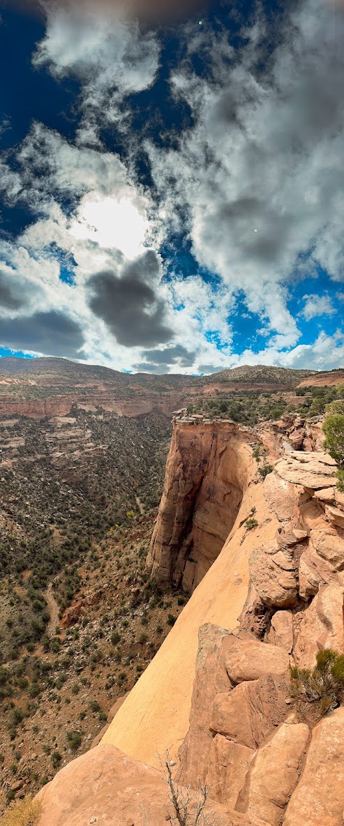
Equipped only with my iPhone 15, I took many pictures including the one of David. Here are some of those pictures.


This is a vertical panoramic view


On a ledge far away, an astute nearby observer noticed these guys. Turns out she was a naturalist from the National Geographic. Too bad I had the wrong camera and lens.


Meanwhile, it was time for these cliff dwellers to leave.


The next morning, we awoke at an ungodly hour, drove to the airport, said goodbye to our rental car, and boarded the great silver bird for our ride home.

Saturday, October 19, 2024

About Drones


I was determined to advance my skills as a drone pilot while I was in Utah. The learning curve is not trivial. My skills did improve, although not as much as I expected.

On day one, upon taking off, I got confused about the controls, lost sight of the drone, and the screen got messed up in a way that I could no longer see what the drone was seeing. Finally I saw the drone several hundred feet away over an inaccessible rock field. There are two buttons which trigger an automated landing. The button I intended to push brings the drone home and lands at the spot that it took off.

I suspect I pressed the wrong button, instructing the drone to land at the spot directly below its current position. I panicked because I did not know how to abort the landing. I was saved by on onlooker pilot who hastily showed me which button to press to abort. That done, we were able to bring the drone back and the day was saved - an inauspicious start! I almost lost my drone that day.

By the next day, I was brave enough to launch the drone again. Day 2 went much better than day 1. Here is one of my excursions.


On day 5 at the Silver Spire, I had another chance to fly. However, the situation did not allow for me to have sufficient one-on-one time with Caryn. Furthermore, two drones belonging to our group had already crashed that day, and were damaged beyond repair. I chose to take lots of still photographs instead. What follows is a video created by Caryn.


Drone Video by Caryn Esplin

Day 5 - The Silver Spire and Rainbow Mountains

 I believe it is fitting to begin this record of the last day of our workshop with my last photograph taken on that final day.

The Silver Spire, sunset


This was our best day. The day was supposed to begin at 5 AM, but our fearless leader learned that the road to The Silver Spire was unsafe due to mud. Although we did miss the sunrise, we did get to sleep in to  7 AM! 

Our plan was to again visit the Rainbow Mountains from a closer vantage point, and then spend the rest of the afternoon and evening at the Silver Spire. The locals have a different name for the spire, but I will leave the discovery of that name as an exercise for the reader. A major activity of the day was flying and photographing with drones. This is a big subject which I will leave for a separate entry.

The vehicle of choice for today's outing was the All Terrain Vehicle (ATV), and that was entirely appropriate. Although the road was too muddy in the morning for safe passage to the spire, it had dried somewhat under the sun by mid afternoon. So, off we went in our fleet of seven ATV's.

Kaylin is navigating golfball and some baseball size chunks of wet clay that are being flung at us by the wheels ahead of us and our own wheels.

Kaylin determined to get that shot!


The closest ATV is ours. There was a layer of clay chunks several inches deep on the floor of the cab.


We felt battered when we emerged from that ride. Wet clay was everywhere. We had to somehow clean our glasses - with what? Mud was in our pockets, inside our clothes - everywhere.
Onward! We were here to make pictures!!


Keith, onward and upward


After lunch, it was time to move on to the Silver Spire, our final destination on our final day. There, Bob and I would climb to a good vantage point and spend the next two hours taking many pictures.


It was a bit of a trek for us septuagenarians  to get to this perch. Once here, Bob and I stayed put for the duration.


The clouds and the light were constantly changing. Although we remained in the same place, the scenery was constantly changing.


On a technical note, the photos were taken with a Sony ⍺6700 which has an APS-C detector. The lens for most of the shots was a Tamron 11-20mm zoom. Most of the pictures are HDR merge with 3 images, with shutter speed quadrupling and re-quadrupling. The shutter speeds ranged from hundredths of a second to 8 seconds. Post-processing was done mostly in Adobe Lightroom. After HDR merge, the exposure setting, contrast, white balance, texture, clarity, and dehaze were typically manipulated. Most of the images were taken toward the 20mm end of the zoom. The last image was taken with an 11mm setting, and the spire appears tilted. It was not falling over. I believe this is an artifact from the wider angle.
Thus ends the saga of Bob and Eric in the middle of southern Utah. Leaving our slope in the dark was not as easy as getting there. Keith assisted us, and we got down in one piece. We are grateful for his patience. Had I complained, Bob would have reminded me that we need to know our limitations and exceed them frequently.

Friday, October 18, 2024

Day 4 - Photo Editing Tutorial

We have had long and busy days taking hundreds of pictures from dawn to dusk. Today is dedicated to honing our skills editing all those pictures. A large range of topics was discussed. Several computer applications were reviewed. Most discussed were Adobe  Bridge and Lightroom, and Luminar Neo.

The session was just what I needed to boost my performance particularly with Lightroom. Over the years I have been using Lightroom primarily to organize and store what is now over 60,000 photographs. Lightroom has powerful editing tools as well, but I have not used most of them. Since the workshop, I have begun to use those tools with tremendous results. I am just beginning to learn about Luminar.

After today's workshop, Bob and I took it easy. We shared many tricks for editing photos. I began working on the photos I had been taking over the past three days.

We both turned in early in preparation for the fifth and final day of our Utah Badlands experience.

Thursday, October 17, 2024

Day 3 - Goosenecks Overlook and Capitol Reef National Park


Google Maps satellite view


We left Hanksville at 6 AM and headed west on route 24 for a 7:33 AM sunrise atop the Overlook in Goosenecks State Park. After a climb, we found ourselves with a clear view of the eastern horizon, and on the brink of an awesome canyon. There in semidarkness, we set up our tripods and adjusted our cameras to take triplets of frames at different Æ’ stops to best capture the sunrise. We were not disappointed.

7:25:53 AM


7:31:23 AM


7:33:35 AM


These are some of the finest photographs I have ever taken. And yet, they cannot begin to rival seeing the beauty of actually watching the sky changing by the second during the transition from dark to light.

As it got lighter, we focused our attention on the canyon which was carved by the San Juan River.


Here is a satellite image of the San Juan River as it snakes through the park.


After lunch, the group split into two. The youngsters headed for a steep hike to Hickman's Bridge. The senior members explored other wonders of the Capitol Reef National Park. Then the rain came. They got soaked. We stayed pretty dry.


The Capitol Reef National Park is also known for petroglyphs. These are engraved etchings into rock walls created by the Fremont and Puebloan people who considered what we now call Utah their home, well before our immigrant ancestors showed up. The petroglyphs  were created between 600-1300 A.D. They are reasonably well preserved, despite the efforts of descendants of immigrants to deface them a thousand years later.

     Here are a few:


The Park is also known for the preserved school house serving the children of the town of Fruita.


Also preserved in the town of Fruita are a barn and a home which now houses a bakery. We had to get to the bakery early in order to get our fruit pies for lunch. There were also unusual food items to be had.


Enjoy!


Parting shot (iPhone 15)


Wednesday, October 16, 2024

Day 2, Part 2 - Temples of the Sun and Moon

 After an exciting morning overlooking southern Utah's moonscape and Factory Butte, and after a wonderful lunch provided by Outlaw's Roost, we moved on to the Rainbow Mountains, and later to the Temples of the Sun and Moon. The main feature of this outing would be the rising of the moon, minutes before sunset. The moon was not only full, it was a supermoon.

The distance between the earth and moon varies. Three or four times a year, the full moon coincides with the moon being closest to planet earth. When that happens, the moon appears 14% bigger and 30% brighter than it does when the full moon is furthest away from earth. When the moon is at its closest, it is called a supermoon. NASA has a page explaining the supermoon phenomenon.


We spent some time photographing the Rainbow Mountains, fully expecting to get drenched. We watched as the storm and occasional lightning got closer, a few drops of rain fell - and that was it!


We moved on to the Temples of the Sun and Moon.
This was taken about one hour before sunset.


Taken about 30 minutes after moonrise


This was the end of day two. We needed to sleep.